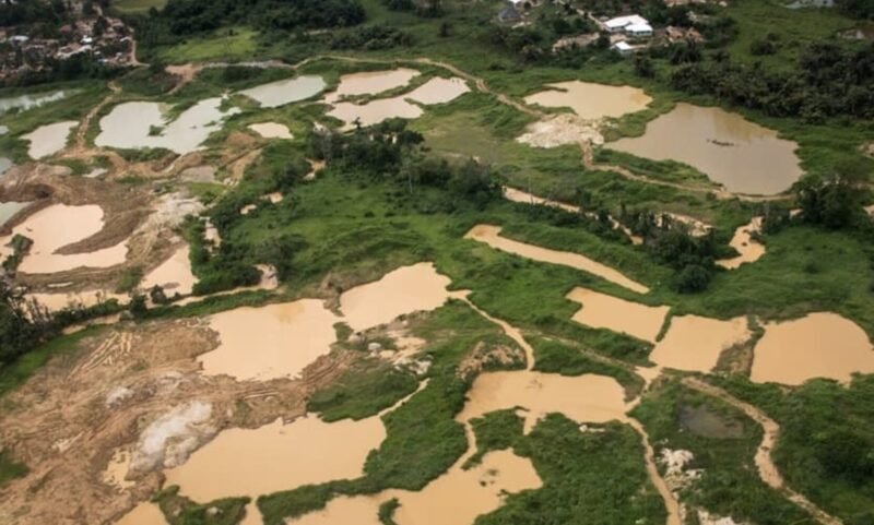
The illegal gold mining menace – galamsey – has mutated into a national crisis. Forests decimated, rivers poisoned, and farmlands devastated. Over 4,000 excavators are either awaiting clearance or en route to Ghana’s ports, threatening to turn vast landscapes into open pits.
Faced with this environmental invasion, Ghana can no longer rely on outdated tools. It’s time to deploy a technological counterforce – one that’s already transforming battlefields and smart cities across the world.
Satellites Can Spot the Miners Before They Dig
Commercial satellites can now deliver images of such high resolution (30 cm per pixel) that analysts can detect a single excavator, a man with a shovel, or muddy water from mining runoff. These tools can identify:
● Newly cleared land.
● Sediment-laden rivers.
● Shifts in vegetation.
By integrating these into a geospatial AI model, Ghanaian authorities can predict where Galamsey may occur next, enabling preventative patrols.
Virtual Fences, Real-Time Alerts
Authorities can overlay virtual fences (geofencing) on top of legally licensed mining zones. If any disturbance is detected outside these zones, real-time alerts are sent to a central dashboard and on-ground forces.
● Combined with machine learning, this system can:
● Detect early warning signs of illegal mining.
● Match satellite-detected activity with licensing data.
● Generate heat maps of high-risk areas.
Drone Fleets for Day and Night Surveillance
Ghana must invest in expendable fleets of drones – already battle-tested in global conflicts – for targeted, localised reconnaissance:
● Fixed-wing drones map large areas quickly.
● Multirotor drones zoom in on riverbanks and forests.
● Thermal drones detect movement and heat signatures after dark.
● Live drone feeds guide security teams directly to illegal sites, eliminating delays and reducing the danger of ambush.
A War Room Without Guns
This isn’t about militarising the problem – it’s about strategic coordination. Ghana’s proposed Galamsey War Room will serve as a:
● Tactical command centre, integrating all surveillance feeds.
● Data fusion hub, pulling in satellite, drone, and citizen reports.
● Action launcher, triggering security responses and legal follow-ups.
Stakeholders from the Minerals Commission, security agencies, and local communities would collaborate here in real-time.
Justice Through Imagery
Illegal miners often walk free due to weak legal evidence. Satellite and drone data will now provide court-grade documentation – photographs, videos and timestamps – ensuring higher conviction rates.
The Human Factor: Local Heroes and Grassroots Reporting
Technology must meet people where they are:
● Train community leaders as “first responders.”
● Launch citizen-reporting apps that accept photo evidence in any language.
● Use open-access digital maps to show progress and deter would-be offenders.
This bottom-up approach ensures public trust and cooperation.
The 18-Month Action Plan to End Galamsey
3 Months: Pilot satellite monitoring, train analysts.
6 Months: Activate War Room, deploy drones, and integrate national GIS data.
9 Months: Launch legal reforms, rapid-response units.
Ongoing: Review technology, community engagement, and simulate emergencies.
Final Word: From Crisis to Continental Leadership
Galamsey is not just an environmental issue – it’s a national emergency. Ghana can win this battle by combining satellite-scale visibility, drone-level precision, AI-powered prediction and community-level trust.
DISCLAIMER: The Views, Comments, Opinions, Contributions and Statements made by Readers and Contributors on this platform do not necessarily represent the views or policy of Multimedia Group Limited.
DISCLAIMER: The Views, Comments, Opinions, Contributions and Statements made by Readers and Contributors on this platform do not necessarily represent the views or policy of Multimedia Group Limited.


